• Menu
  • Skip to primary navigation
  • Skip to main content
  • Skip to footer

Cape Cod Lighthouses

  • Home
  • Lighthouses
    • Chatham Light
    • East Chop Lighthouse
    • Gay Head Light
    • Highland Light (Cape Cod Light)
    • Lewis Bay Lighthouse (Hyannis Harbor Light)
    • Long Point Light
    • Monomoy Point Lighthouse
    • Nauset Light
    • Nobska Point Lighthouse
    • Race Point Light
    • Stage Harbor Lighthouse (Harding’s Beach Lighthouse)
    • The Three Sisters
    • West Chop Lighthouse
    • Wings Neck Lighthouse
    • Wood End Light

cape cod

Gay Head Light

March 16, 2023 //  by sgadmin

Close up view of Gay Head Lighthouse on Martha’s Vineyard on Cape Cod

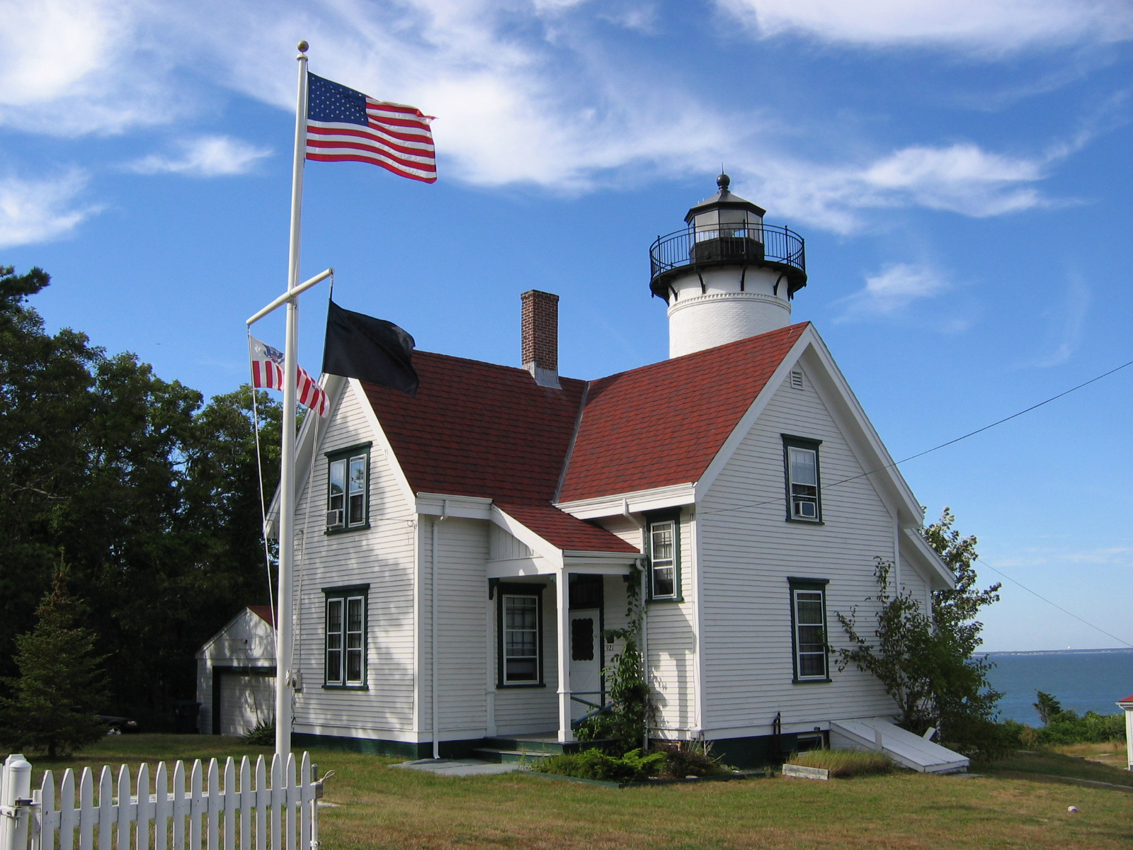
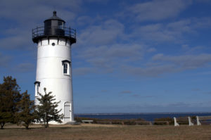
History of The Gay Head Lighthouse

The Gay Head Light holds the notable honor of being the first lighthouse constructed on Martha’s Vineyard. In 1796, Senator Peleg Coffin suggested the construction of the lighthouse.

During this time, there was a healthy whaling industry off the coast of Massachusetts. Sperm whales were an important industry for the region. The oil harvested from sperm whales was highly prized for burning brightly and cleanly in the oil lamps of the day. The whalers needed the lighthouse on Gay Head because of a treacherous section of rocks called the “Devil’s Bridge.”

The construction and maintenance of lighthouses and other forms of navigation along the coast of the young United States was the responsibility of the federal government. Congress approved $570 to build the lighthouse. In 1799 the Commonwealth of Massachusetts deeded more than two acres of land for the building of the lighthouse. The contract for the 47 foot tall octagonal lighthouse with a keeper’s house was approved by President John Adams.

There was some concern, though, that whomever was given the position of lighthouse keeper would create issues in the local Wampanoag nation. The Wampanoag were, and remain, the ancestral owners of the land the lighthouse resides on. In the end, though, this was not taken into consideration in the choosing of the keeper.

The light first came on November 7, 1799. The first lamp was likely a multi wick “spider” lamp with a pan of sperm whale oil as the fuel. While sperm oil was considered the most clean fuel option for lamps at the time, the reality was that it still produced significant amounts of ash. An important part of the lighthouse keeper’s job was keeping the casing clean so the light could be seen from the water. There was also the issue of ensuring the light flashed on the correct pattern. This functioned via a wooden clockwork mechanism that would swell and stop functioning in the summer months. All this made the lightkeeper’s job very challenging.

With some upgrades to cleaner burning, more efficient parabolic lens lamps the Gay Head Light continued in operation until 1844 when it was determined that the clay cliffs had eroded putting the lighthouse structure at risk. The lighthouse was moved further back along the cliff at a cost of $386.87.

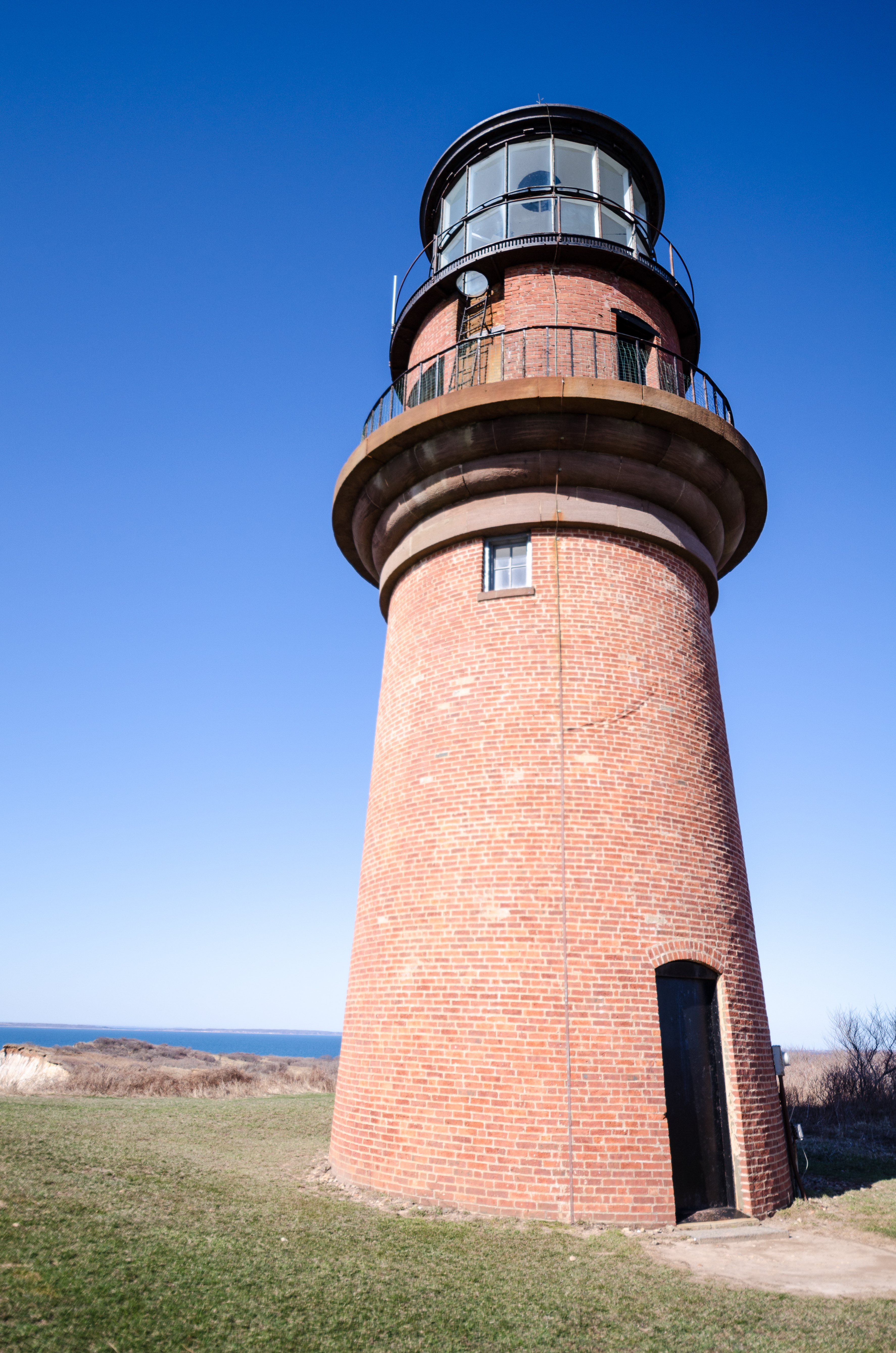
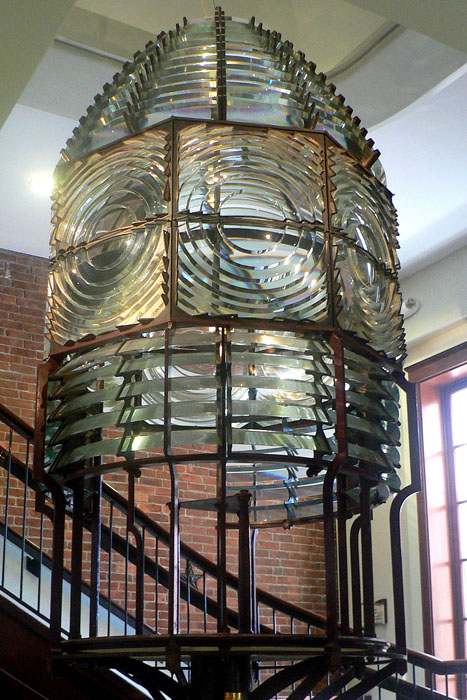
By the 1850s, though, the building was in such disrepair that the eroding cliffs were again threatening it. After an extensive 760 page report, it was determined that the old wooden structures needed to be replaced by stronger brick ones and the lamp would be replaced with the new Fresnel lens technology.

The Fresnel Lens was an impressive feat of engineering. In fact, when the Parisian firm, Henry LePaute, who built the lens, entered it in the 1855 Exposition Universelle and took away the grand prize. The Fresnel lens is so impressive because it uses prism technology to create a bright light with much less glass. It still weighed a ton and was very difficult to transport to Gay Head and up into the new brick tower. The new light was so bright that when it was first turned on, it was confused with other lighthouses along the coast. In 1874 red panels of glass were added to further distinguish it. This famously gave the flash pattern of “three whites and one red.”

Over this time, the fuel used to keep the lights burning underwent a series of changes. While the sperm oil was an appropriate choice, given that it was the result of the whaling industry the lighthouse supported as well as being clean burning, eventually its cost became prohibitive. The lighthouse moved on to the less expensive coiza oil (made from wild cabbages) then to lard oil in the 1850s. The 1870s and 1880s brought the innovation of Kerosene. Electrification did not come to Gay Head until 1954.

The next big change for the Gay Head Light was the replacement of the light keeper’s house in 1902. Over the previous decade, several of the lighthouse keeper’s children died under mysterious circumstances, later determined to be from the mold and mildew of the house. This necessitated the new structure.

In 1920, Charles W. Vanderhoop, Sr, a member of the Wampanoag nation, was promoted to principal lighthouse keeper. This is particularly notable as he was the only member of the Wampanoag nation to serve in that position.

The old Fresnel lens was in use until electricity finally made its way to the island in the 1950s. In 1952 the lens was moved to Edgartown, Massachusetts to be a part of the Martha’s Vineyard Museum. Because of his dedication, it was decided that Vanderhoop would light the Fresnel lens in the new exhibit.

From 1956-1985, the automated lighthouse was infrequently maintained by the US Coast Guard. There was a national push to decommission the old lighthouses. They were costly to keep in service and increasingly obsolete in a world of new maritime navigation aids like satellite GPS.

In the 1980s, the Vineyard Environmental Research, Institute’s (VERI) helped fight for the preservation of three lighthouses slated for demolition, including Gay Head. Help pushed along by Senator Edward Kennedy, in 1985 the US Coast Guard gave VERI the responsibility of the three lights for 35 years. Extensive preservation took place, pointing bricks and remediation of toxic mold eventually ending in the placing of Gay Head Light on the National Register of Historic Places.

In 2015, the lighthouse was once again relocated to accommodate the continued erosion of the clay cliffs It’s current location is expected to remain safe for the next 100 years.

There is evidence that the lighthouse was open to visitors from its very earliest days. It became even more of a destination after the addition of the Fresnel lens. As the building deteriorated and the public was less impressed with the Fresnel design, guests became much more of a rarity. After the transfer of ownership to VERI, though, the lighthouse was again open to the public on Mother’s Day in 1986. Since then it has opened to tourism in the summers, even being toured by President Barack Obama during his vacation on the Vineyard.

It is a continued challenge to keep the lighthouse open and operational. With an over two hundred year old property, there is a lot to be done to keep it around for future generations. The realities of the environmental impact of erosion and acid rain are a constant battle. This has been taken on by the Town of Aquinnah through the formation of its “Save the Gay Head Lighthouse Committee. The fight continues to raise the funds to keep this historic landmark alive.

Cape Cod Modern Tourism

People visiting cape cod today can still visit this historic lighthouse and take it it’s stunning views.

The lighthouse can be found at 65 State Road, Aquinnah, MA 02535, phone number 508-645-2300 (ext. 0).

The light is open to the public mid June-mid October daily from 10 am – 4 pm

Sunset viewing available Thursday and Friday nights from 6:00 pm – 8:00 pm

The light is not open when it is raining.

Accommodations Near Gay Head Lighthouse:

While there are no accommodations on site, there are several hotel options near the lighthouse.

The Outermost Inn and Duck Inn are quaint guest houses offering stunning views of the Atlantic ocean and a quick walk to the Aquinnah Public Beach. There are also a variety of rental properties available on Martha’s Vineyard proper.

Things to do near Gear Head Lighthouse:

An unique aspect of the Gay Head Light is the opportunity to learn about the Wampanoag who still reside on their ancestral land at Aquinnah. Near the lighthouse is a museum about Wampanoag history and culture.

No trip to the Gay Head Light would be complete, of course, without a visit to the Martha’s Vineyard Museum to see the Fresnel lens. The light received a new setting in 2019 so that modern visitors can see it in its full glory.

Restaurants near Gear Head Light:

Most of the food in the area is focused around seafood culture but there are plenty of options for everyone. Recommended dining establishments nearby are Chillmark Tavern,  Orange Peel Bakery and Menemsha Fish Market.

Though the lighthouse itself does not offer tours, they do host a variety of events during the summer season such as a 10k race and sunset viewings.

The lighthouse is included on several general and lighthouse tours given by Martha’s Vineyard Tours and Excursions as well as the Martha’s Vineyard Museum itself.

Gay Head Light is a bit off the beaten path but it is well worth the trip. In addition to this historic lighthouse, the views of the Atlantic Ocean are not to be missed. In addition, the opportunity to visit the public beach and enjoy the natural rugged landscape can’t be beat. It is also a particular treat to the opportunity to learn about the lives of the Wampanoag and their civic relationship with the surrounding area.

Category: Gay Head Light, LighthouseTag: cape cod, cape cod lighthouse, lighthouses

Cape Poge Lighthouse

June 28, 2020 //  by sgadmin

As part of Martha’s Vineyard off the Cape Cod coast, the Cape Poge Lighthouse is located in the northeast corner of Chappaquiddick Island. It is part of the Cape Poge Wildlife Refuge. In 1987, the lighthouse was added to the National Register of Historic Places. The lighthouse is owned and operated by the Trustees of Reservations, but the light is operated by the United States Coast Guard. In the movie “Jaws”, as Roy Scheider and Richard Dreyfuss swim to shore, the Cape Poge lighthouse appears on the right side of the screen. Visiting the lighthouse requires a four-wheel-drive vehicle and a 3.5-mile hike from Dike Bridge, or you can arrange to be picked up when you schedule a tour.

History of the Cape Poge Lighthouse

The original 35-foot, octagonal, wooden tower and the two-room keeper’s house were built on four acres in 1801 for $2,000, including $36 for the land. The lighthouse helped whaling ships navigate the Muskeget Channel and Cape Poge on their way to Edgarton Harbor. The original light was equipped with a spider lamp, which is a lamp with multiple arms and a light at the end of each arm. In 1812, the lamp was replaced with oil lamps and reflectors. It was turned off for several months during the War of 1812 after the British burned Washington. The keeper, Matthew Maybew, took the parts of the lamp four miles away and hid them in the basement of the home of Samuel Huxford in Chappaquiddick. In 1815, the light was relit, and the keeper’s house received an additional room in 1816.

By 1825, erosion had worn away half of the original four acres. Four more acres were purchased, and the lighthouse was moved by the keeper’s brother for $250. It was moved again in 1838 when again, thanks to erosion, the lighthouse was only 40 feet from the edge. Then, it was rebuilt in 1844 for $1,600. A walkway connecting the new tower to the keeper’s house. The house as enlarged around 1868. A fourth-order Fresnel lens was installed in 1857. By 1870, more erosion put the keeper’s house in danger, so, another four acres of land were purchased. A duplex was built for the keeper and an assistant keeper in 1880.

The current lighthouse was built 40 feet inland in 1893. Rather than build a new lantern room, a 35-foot high, 40-foot long staging was constructed, and the lantern room was moved from the old tower to the new tower in one day. The new lighthouse had to be moved 50 feet in 1907, 95 feet in 1922, 150 feet in 1960, and 500 feet in 1987. The 1987 move made the Cape Poge Lighthouse the first lighthouse moved by helicopter.

The light was changed from a solid white light to a red and white flashing light in 1898, which meant that every five or six hours a clockwork mechanism had to be wound. The new light had six flash panels and was a Chance Brothers fourth-order Fresnel lens from England. The lighthouse was automated in 1943, so the keeper’s house was no longer needed. It was used by the Coast Guard during World War II. Then, the keeper’s house was sold in 1954 and torn down. The light was replaced by a solar-powered, 12-inch, 300-millimeter lens that flashes a white light every six seconds. In 1997, the lantern room was removed and transported by helicopter to Falmouth, and then, by truck to New Bedford for cleaning and refurbishing. The project took two months. In 2001, a bicentennial celebration was held at the lighthouse.

Even with the lighthouse, there have been incidents around Cape Poge. The Hudson, a schooner, sank between the time of Mayhew’s death in December 1834 and the arrival of his replacement. It is unclear if the light was lit. Other reported shipwrecks in the area include the schooner, Sarah Lewis, in March 1853; a schooner, the Silver Bell, in 1856 on East Beach; the brig, Empire, in 1856; the schooner, Christiana, on Hawes Shoal on January 7, 1866; and a six-masted schooner, the Mertie B. Crowley off Wasque in 1910.

Location and Hours of Operation

Address: 59 Lighthouse Roadside, Edgarton, Massachusetts

Phone: (508) 627-3599

Hours of operation: The Cape Poge Wildlife Refuge is open daily from 5 am to 10 pm.

Nearby Accommodations

There are no accommodations directly connected to the Cape Poge Lighthouse or the Cape Poge Wildlife Refuge. However, the Trustees of Reservations, who manages the Cape Poge Wildlife Refuge, have a cottage available to rent at the nearby Longpoint Wildlife Refuge, and camping is available at Dunes Edge Campground in Provincetown, Massachusetts.

Hotels Near the Cape Poge Lighthouse

Ashley Inn
Address: 129 Main Street, Edgartown, Massachusetts
Phone: (508) 627-9655
Rooms 10
Amenities Cable TV, WiFi
Awards: Editor’s Choice Award — Cape Code Travel Guide.
The house was built in 1860 by a Captain who retired from the whaling industry and remained in the family through the Captain’s granddaughter. In 1983, it was opened as an inn.

Vineyard Square Hotel and Suites
Address: 38 North Water Street, Edgartown, Massachusetts
Phone: (508) 627-4711
Rooms 34 rooms from one-bedroom to suites, including dog-friendly suites
Amenities Vineyard Square provides board games and cribs as well as an in-season continental breakfast, afternoon treats, in-room taffy, room service, complimentary bikes, and beach chairs, towels, and umbrellas to take to the beach. In addition, they have a 24-hour fitness center; a full-service spa, the Sea Spa Salon; an art gallery, Eisenhauer Gallery; and a boutique, Mikel Boutique. Their on-site restaurant, Chesca, offers seafood, beef, chicken, Japanese, and Italian cuisine. They offer yoga and fitness retreats, meeting facilities, and wedding packages.
Awards: TripAdvisor — Certificate of Excellence
The Vineyard Square Hotel was originally called The Colonial Inn. In 1835, a Methodist camp meeting inspired the idea of Martha’s Vineyard as a summer retreat.
In 1911, Thomas Henry Chirgwin built The Colonial Inn. It had 16 rooms, electric lights, hot and cold baths, steam heat, and three dining rooms seating 400 and serving three meals a day. The three dining rooms were for either the owner, his family, maids, and chauffeurs; guests’ children and nannies; or adult guests. A year later, 16 rooms were added. In 1921, another building was incorporated into The Colonial Inn. In 1927 a local newspaper mentioned that the hotel included 60 rooms spread among the main building and three other buildings.

The hotel was acquired by new owners in 1964 and a new management team in 1966, who brought back breakfast and lunch service and added a gourmet cuisine to the hotel. The new management team also named rooms after books by Somerset Maughan, who had been a frequent guest at the hotel in the 1940s. The hotel was sold again in 1967 and received a license to sell alcohol at that time. After another sale in 1973, the dining room was replaced by a 500-person nightclub with live music. In 1984, the nightclub was replaced by a 50-person restaurant and retail space. Another sale in 1986 saw renovations, including private bathrooms in every room. A sale of the hotel in 1999 resulted in some of the retail space being converted to a spa, fitness room, and meeting rooms. Renovations in 2006 reduced the 43 rooms to 34, including six one- and two-bedroom luxury suites. In 2009, the hotel changed ownership again and was redecorated in beach modern style in 2011. That is when it became Vineyard Square Hotel and Suites.

Harbor View Hotel
Address: 131 North Water Street, Edgartown, Massachusetts
Phone: (508) 627-7000
Rooms 114, including some cottages
Amenities The location of the Harbor View Hotel allows for beach access. Other amenities include WiFi, a 36-inch flat-screen TV, cable, a desk, kitchens in some rooms, cribs, dog-friendly rooms, bathrobes, a hairdryer, toiletries, an iron and ironing board, room service, a concierge, a front desk safe, multi-lingual staff, newspapers in the lobby, a full-service laundry, a dry cleaning service, bicycles, beach towels, a pool, and poolside bar. The hotel also includes a fitness center, wedding packages, meeting facilities, a fireplace in the lobby, and Bettini, a restaurant and bar that offers seafood, beef and Italian cuisine
Awards: Member Historic Hotels of America
Built in 1891, the Harbor View Hotel grand opening was by invitation only and was attended by 400 hotel guests and Edgarton residents. The hotel was part of a plan by city leaders to attract tourists after the whaling industry declined. It has successfully continued to attract guests.

Restaurants Near the Cape Poge Lighthouse

Alchemy
Address: 71 Main Street, Edgartown, Massachusetts
Phone: (508) 627-9999
Restaurant type: Alchemy is a fine-dining restaurant, a bistro, and a bar featuring American cuisine with a European flair.
Menu Items on the menu feature seafood, beef, pork, and chicken.
Awards: 2019 Wine Spectator Award of Excellence.
Best Cocktails on the Island — Martha’s Vineyard Magazine

Détente
Address: 15 Winter Street, Edgartown, Massachusetts
Phone: (508) 627-8810
Restaurant type Détente is a fine-dining restaurant and a bistro.
Menu Items on the menu feature locally sourced and seasonal contemporary American cuisine with a European flair and include seafood, beef, and pork.
Awards: Travel Advisor Certificate of Excellence 201- to 2019
Top Zagat rated restaurant

L’etoile
Address: 22 North Water Street, Edgartown, Massachusetts
Phone: (508) 627-5187
Restaurant type L’etoile offers fine dining with a bar.
Menu Items on the menu feature locally sourced and seasonal contemporary French and American cuisine including seafood, beef, and pheasant.
Awards: Travel Advisor Certificate of Excellence 2016 to 2019
Find a Table Diner’s Choice Award 2019

Wharf Pub
Address: 3 Main Street, Edgartown, Massachusetts
Phone: (508) 627-9966
Restaurant type Wharf Pub is a family-friendly American-style pub and restaurant with live music.
Menu The menu features seafood.
Awards: Travel Advisor Certificate of Excellence 2016 to 2019

Tours

Daily tours of the Cape Poge Wildlife Refuge and the lighthouse are offered starting near the end of May. You actually are allowed to climb up to the lantern room. Tours are offered from 10 am to 11:30 am, 12 noon to 1:30 pm, and 2 pm to 3:30 pm.

Unique features of Cape Pogue:

The light is 65 feet above mean high water and can be seen from a distance of nine miles. The 35-foot high, conical-shaped tower is white with a black lantern. It is covered with shingles. With all the updates it has received, the lighthouse does not have a foghorn.

Places to Eat Nearby

The Seafood Shanty
31 Dock St, Edgartown, MA 02539, United States
http://www.theseafoodshanty.com/
6.7 miles

Quarterdeck Restaurant
29 Dock St, Edgartown, MA 02539, United States
None
6.7 miles

Among the Flowers Café
17 Mayhew Ln, Edgartown, MA 02539, United States
http://amongtheflowersmv.com/
6.8 miles

The Wharf
3 Main St, Edgartown, MA 02539, United States
http://www.wharfpubmv.com/
6.8 miles

Rockfish
11 N Water St, Edgartown, MA 02539, United States
http://www.rockfishedgartown.com/
6.8

Nearby Accommodations

Kelley House Hotel
23 Kelly St, Edgartown, MA 02539, United States
http://www.kelley-house.com/
6.7miles

The Lightkeepers Inn
25 Simpsons Ln, Edgartown, MA 02539, United States
http://www.thelightkeepersinn.com/
7 miles

Harbor View Hotel
131 N Water St, Edgartown, MA 02539, United States
https://www.harborviewhotel.com/
7 miles

Edgartown Commons
20 Peases Point Way, Edgartown, MA 02539, United States
http://www.edgartowncommons.com/
7.2 miles

Hob Knob
128 Main St, Edgartown, MA 02539, United States
http://www.hobknob.com/
7.3 miles

Things to Do Nearby:

Mytoi Japanese Garden
41 Dike Rd, Edgartown, MA 02539, United States
http://www.thetrustees.org/places-to-visit/cape-cod-islands/mytoi.html
3.7 miles

Eisenhauer Gallery
38 N Water St, Edgartown, MA 02539, United States
http://www.eisenhauergallery.com/
6.8 miles

Old Whaling Church, Edgartown Liturgical Arts Center
89 Main St, Edgartown, MA 02539, United States
http://mvpreservation.org/properties/old-whaling-church/%20or%20umc-mv.org
7.3 miles

Vincent House Museum
99 Main St, Edgartown, MA 02539, United States
no link

7.3 miles

Lighthouse Beach
230 N Water St, Edgartown, MA 02539, United States
none
7 miles

Category: Lighthouse, UncategorizedTag: cape cod, cape cod lighthouse

East Chop Lighthouse

April 26, 2020 //  by sgadmin

East Chop Lighthouse, Martha’s Vinyard Massachusetts

History of the East Chop Light

Chop is one of those words that can have an extraordinarily different meaning for those living in ocean towns than those who do not. When one sees the East Chop Lighthouse, the meaning is perhaps clearer. A chop, as referenced in this light sitting atop Telegraph Hill, refers to the entrance of a body of water. In the case of this Martha’s Vineyard landmark, it is one of a pair of lights illuminating the entrance of one of Martha’s Vineyard’s harbors.

While East Chop’s pair, West Chop, was established in 1817, East Chop remained without a light for the first half of the 19th century. In 1828, a semaphore station was built, giving Telegraph Hill its name, but residents knew that a light was necessary at the spot.

Governments would usually approve and install these important navigation aids but in 1869, a local resident, Captain Silas Daggett took matters into his own hands. Captain Daggett took it upon himself to build his own lighthouse, then advertised it in several newspapers with the following advertisement:

The undersigned has at a considerable expense erected a Lighthouse (to be known as the “Coaster’s Light”) on the East Chop of Holmes’ Hole Harbor. The height of the lantern above the level of the sea is about sixty feet, from which a fixed red light will be exhibited on and after June 5. Captains, owners and underwriters of vessels cannot fail to appreciate the convenience of the Light, and should therefore be willing to contribute to its support. Silas Daggett, Branch Pilot, Holmes’ Hole, Mass.

Captain Daggett was correct in thinking that local seamen and business owners would see the value of the East Chop Light. The light was maintained with donations from local business owners and of ships that docked at Vineyard Haven.

In 1871, the East Chop Light was heavily damaged in a fire forcing Captain Daggett to rebuild. This time, Captain Daggett got assistance from The Lighthouse Board. The Organization loaned him three twenty-one inch reflectors allowing him to maintain the fixed red light. With the new structure, the light was 76 feet above sea level.

The East Chop Light continued on as an independent enterprise for several more years, despite The Lighthouse Board publicly recognizing its need in 1873. In 1875, Congress finally appropriated the funds to build a proper East Chop Light and purchased the property from Captain Daggett the next year.

In 1877, construction began on a replacement light for East Chop. Captain Daggett’s original remains to this day as a part of a private home about fifty feet away. The new lighthouse would be a forty-foot-tall, cast-iron, conical structure with a nearby one and half story house for the lighthouse keeper.

Once construction was completed, a fourth-order Fresnel lens was installed at 79 feet above sea level. Initially the Fresnel lens was set to shine a solid white but in 1898 it was changed to flashing red. The light was changed once again in 1934 to a flashing green.

The Fresnel lens was an important innovation in lighthouse technology. Fresnel lens’ are constructed from a series of prisms, allowing for greater brightness with less glass and fuel usage. They come in a variety of orders which determine the size and focal length of the light.

To create the lights, a variety of fuels were used over the years. By the end of the 19th century, lighthouses were moving from the dirtier and more expensive sperm whale oils and lard oils to the cleaner burning, cheaper but more volatile kerosene. In 1898 a dedicated oil house was built near the East Chop Light to house the dangerous but effective fuel.

When this most recent cast-iron East Chop Light was built, it was originally painted white. Not long after it was built, sometime in the 1880s, the more typical white was replaced with a reddish brown. Locals were very fond of their unusually colored light, referring to it as the “Chocolate Lighthouse.” Unfortunately the darker color caused numerous heat and restoration issues so it had to be repainted white in 1988.

While the history of the various lighthouses on Martha’s Vineyard are in and of themselves fascinating, even more engaging are the stories of the people who manned them. The East Chop Light is blessed with one of the more colorful characters from lighthouse history, George Walter Purdy.

Purdy started as a lobsterman in Newfoundland eventually moving to Massachusetts and becoming a lighthouse tender on the ship Azalea. While on the Azalea, Purdy got his sleeve caught in some of the machinery, heavily damaging his arm. By the time the ship returned to port, gangrene had set in, forcing the arm to be amputated.

While losing his arm forced Purdy out of his work on ships, he was able to continue his marine career in lighthouses. He moved around quite a bit before settling in at East Chop in 1912, remaining there until 1934. He raised several children there. His daughter, Alice Purdy Ray, remembered their time at East Chop fondly many years later.

The house there, they don’t build them like that anymore…The roof was slate. In the wintertime it was beautiful. You would never know what the weather was outside if you were in the house. You wouldn’t know whether it was raining, blowing, sleet. The house was so solid it wouldn’t show anything. It was just as nice and warm as could be. In the summertime it was cool.
There was another building they called a tool shed, and there was a barn across the street. You see, Dad decided he had to have a cow so he asked the town if he could put a cow across the street. There wasn’t anybody there. It was just open field. They said, “Go ahead,” so he went out and bought himself a cow.

And we used to have a vegetable garden. You should have seen the garden my family used to have in there. Oh, those rambling roses. They’re still growing wild along the fence in front.

Purdy was also known for doing the work expected of several people, despite having only one arm to work with. He was remembered for moving several heavy boulders to allow the construction of a boat landing on his own. This was done in a manner such that the original purpose of the boulders, preventing erosion, was not hampered.

In 1934, the lighthouse was automated. The Purdy family was given the opportunity to rent the house they had lived in the past 22 years but chose to move closer to town. The house was then demolished which revealed that the wooden walls actually enclosing brick, explaining the surprisingly quiet structure.

While the East Chop Light, with its upgraded beacon installed in 1984, is still an active aid in navigation. It has mostly been replaced by more modern navigation techniques. It’s care was passed in 1985 to the Vineyard Environmental Research Institute (VERI) then to its current owner, the Martha’s Vineyard Museum in 1994.

Visiting the Lighthouse:

The East Chop Light’s address is :
229 East Chop Avenue, Oak Bluffs, MA

And can be contacted through the Martha’s Vineyard Museum at:
508-627-4441

For visitors who wish to see the lighthouse in person, East Chop is open seasonally on Sunday evenings around sunset.

East Chop Light is also viewable from the water from Martha’s Vineyard Sunset Cruises.

Accomodations Near East Chop Light:

There are no accommodations at the lighthouse proper but there are plenty of hotels nearby in Oak Bluffs including the Martha’s Vineyard Surfside Hotel, Hotel Ginger and the Pequot Inn.

Oak Bluffs has a variety of restaurant options near the harbor including seafood restaurants like Fishbone’s Bar and Grill and Nancy’s Restaurant as well as other cuisine options such as the Homespun American food at Linda Jean’s Restaurant or Mexican at Sharky’s Cantina.

The town of Oak Bluffs itself is a fun place to visit. It has a delightful mix of the quaint Martha’s Vineyard architecture with high spirited fun. Of particular note is the Flying Horses carousel, an antique brass ring game carousel from Coney Island, NY.

Both the East Chop Light and the town of Oak Bluffs are both well worth a visit.

Other nearby lighthouses:

West Chop Lighthouse – 13 minute drive – 5.1 miles

Category: East Chop Lighthouse, LighthouseTag: cape cod, cape cod lighthouse

Wood End Light

April 2, 2017 //  by sgadmin

Located miles about an hour and a half to the port of Provincetown, Wood End Light watchtower occupies several acres of sand dunes and there are no other structures in sight. It was lit for the very first time on November 20, 1872 to take the sailors to the lively port of Provincetown.

The Cape Cod Chapter of the American Lighthouse Foundation, known for its excellent work with the restoration and use of Race Point Light over the years, also serves as a guardian to Wood End and long point light. Before Cape Lighthouse was built in 1864, the day of markers were used to guide sailors along the treacherous End wooden bar. Then many boats and their crews fell victim to the wood end bar. Despite the construction of three lighthouses in Provincetown, including Iceland wood Light. Still there were many reports of recent shipwreck that occurred on treacherous bars.

The Long Point Light Station, which was completed in 1875, is an identical design. Topped with a Fresnel lens of the fifth order, 39 meters high, square brick tower, pyramid was painted brown. A half guard wooden house plant was built next to the tower. In 1896, a new house replaced the wooden guard, in addition to a warehouse and an oil house, for the keeper.

What you need to know about Wood End Light

It was in 1896 that the first wooden structure house was built, as well as a warehouse and a small brick house for kerosene storage. This was after may ships fell victim to the treacherous bar and there was a concern that something needed to be done to avoid such disasters.

  • Automate in 1961: – After automation in 1961, the light station was unmanned except all buildings and the tower house and the oil were dismantled.
  • Eight days before Christmas in 1927, the S-4 Navy submarine and the Paulding Coast Guard collided half a mile south of Wood End Light. 40 men on S-4 died in the disaster. S-4 was charged three months later and was used to develop the most important safety measures for future submarines
  • At the tip of Cape Cod winters were hard and kept the Coast Guard from delivering supplies to the station. There was also the fact of the long distance from the lighthouse in the city, this sometimes added to bad weather contributed to supplies not being delivered on time.
  • The light station is equipped with a siren that sounds every 30 seconds
  • Wood end light was converted to be powered by solar energy in 1981. This helped save on spending on gas which was costly at the time and required constant labor to transport the oil and keep watch of the light house to keep refilling so that the lights keep functioning
  • It is possible for you to walk to the wood End of light through the breakwater, which was built in 1911, but the waves are sometimes violently during the flood. It is quite difficult for 30-45 minutes each way to the lighthouse. There is limited parking at the start of the walk. There is an extra walk of about 20 to 30 minutes from the center of the city.
  • The headlamp shows a flashing red light every 10 seconds at 45 meters above sea level, which is visible 13 NM. This enables ships at deep see to notice that they are approaching land or that they are passing near a harbor and need to be careful.

Why visit this lighthouse

Great experience on a hike when you love hiking. If you walk during low tide, you can walk on sand from Iceland Lighthouse on the Long Point Lighthouse tour, which is an additional 1 1/2 miles. The tour of the lighthouse and return to the first landing place is approximately 4 hours. With such a long hiking experience you are sure to have lots of time to bond with whoever you brought with you or meet new people who just came for the same experience. It is an experience of a lifetime that you just have to try if you willing.

Boat rides and ferry services are available to go to the lighthouse where you can discover, experience and enjoy things such as historical tours, whale watching, fishing and other trips that enter the port of Provincetown and disembark. You are sure to have lots of fun and you wont regret having visited wood end light.

As one of the international tourist capitals you will find many activities. Provincetown is one of the largest communities of artists in the state, with its numerous cultural events.

Directions to the Wood End Lighthouse

Take Route 6 to Provincetown Commerce (Route 6)

Turn left onto the shopping street and follow to the end of the street where you can park near the breakwater

To reach the lighthouse, you can hike and then another half mile through the sand to the lighthouse, the mile-long breakwater at low tide.

The Cape Cod Chapter of the American Lighthouse Foundation was authorized by the Coast Guard to restore and maintain Wood End Light. It is still an active aid to navigation today.

Finally, the Beacon Wood End Resort is located at the top of Cape Cod, near the port entrance Provincetown. It is part of the National Park of Cape Cod National Seashore. Coast Guard US keeps optics, which acts as an active navigation aid and is closed to the public. The country and the remaining structures are held by the Cape Cod chapter of the American Lighthouse Foundation. Light Station is restricted though you can access it using 4 wheel drive, but the National Park service won’t probably allow. So the only option you will be able to access the wood end light would be via hiking as even the boats will only pass close by and if you want to view it close hiking will be the best available option and the hike will be fun as you won’t be alone.

Nearby Places to Eat when visiting Wood End Lighthouse

Liz’s Cafe Anybody’s Bar
31 Bradford St, Provincetown, MA 02657, United States
https://lizscafeptown.com/
2.5
Provincetown House of Pizza
50 Bradford St, Provincetown, MA 02657, United States
http://www.ptownpizza.com/
2.5
Bayside Betsy’s Restaurant
177 Commercial St, Provincetown, MA 02657, United States
http://www.baysidebetsys.com/
2.5
Bubala’s By the Bay
183 Commercial St # 185, Provincetown, MA 02657, United States
http://www.bubalas.com/
2.5
Cafe Heaven
199 Commercial St #10, Provincetown, MA 02657, United States
http://www.cafeheavenptown.com/
2.5

Nearby Places to Stay when visiting Wood End Lighthouse

Provincetown Inn
1 Commercial St, Provincetown, MA 02657, United States
http://www.provincetowninn.com/
1
AWOL Hotel
59 Province Lands Rd, Provincetown, MA 02657, United States

AWOL: Not your ordinary Provincetown inn


1.2
The Red Inn
15 Commercial St, Provincetown, MA 02657, United States
http://theredinn.com/
1.5
Land’s End Inn
22 Commercial St, Provincetown, MA 02657, United States
https://www.landsendinn.com/
1.5
Foxberry Inn
29 Bradford Street Ext, Provincetown, MA 02657, United States
https://foxberryinn.com/
1.5

Nearby Things to Do when visiting Wood End Lighthouse :

SEA SPACE Marine Discovery Center
237 Commercial St, Provincetown, MA 02657, United States
http://coastalstudies.org/marine-education-program/sea-space-marine-discovery-center/
2.5
Provincetown Museum
1 High Pole Hill Rd, Provincetown, MA 02657, United States
https://www.pilgrim-monument.org/
2.5

Provincetown Whale Watching
MacMillan Pier, Provincetown, MA 02657, United States
https://www.captainjohnwhalewatchingma.com/
3

Expedition Whydah Museum
16 MacMillan Pier, Provincetown, MA 02657, United States
https://www.discoverpirates.com/research-facilities/provincetown
3

Province Lands Visitor’s Center
171 Race Point Rd, Provincetown, MA 02657, United States
http://nps.gov/caco
4.5 miles from lighthouse


Near the very tip of Cape Cod, Wood End Lighthouse is
now an unmanned light that sounds a horn to alert for fog.
The lighthouse was built in 1872 and the adjacent oil house
was built in 1896.  This remote light can only be accessed by
a long hike.  If you go, be prepared for hot sun,
biting insects and no drinking water.


Wood End Lighthouse with Race Point light
in the background.

For more information and photos of the Wood End Lighthouse,
visit the webpage at the American Lighthouse Foundation.

Category: Lighthouse, Wood End LighthouseTag: cape cod, Wood End Light, Wood End Light lighthouse

The Three Sisters

April 2, 2017 //  by sgadmin

Introduction

The Three Sisters of Nauset are a trio of historic lighthouses off Cable Road in Eastham, Massachusetts. Falling prey to coastal erosion and decay brought by time and poor maintenance, they fell into sea in 1890 and were replaced by wooden towers on brick foundations in 1892. In 1911, two of the three Sisters were decommissioned. One of them, known as the Beacon, was moved back from the shoreline and attached to the keeper’s house. It continued to operate for some time, but ultimately, the Beacon was replaced by the Nauset Light, a new steel tower in 1923, which operates to this day. The Nauset Light Preservation Society operates, maintains and interprets the site, having signed a partnership agreement with the National Park Service since 2004.

Visitors can currently tour the site on Sundays, from May to late October and also on Wednesdays during July and August.

The History of the Three Sisters (286 words)

In 1836, concerned Eastham residents petitioned the Boston Marine Society to recommend to the United States Congress the construction of the Nauset Lights, because of the many shipwrecks regularly occurring off shore. In response, the Congress granted $10.000 to build suitable lighthouses in Eastham, in order to provide a light halfway along the eastern coast of Cape Cod. The contract was awarded to Winslow Lewis, and soon enough three fifteen feet high masonry towers were built, in a straight line along the crest of the cliffs, painted white but with black lantern decks.

They earned their nickname, the “Three Sisters” because when looked at from afar, they looked like black hatted women dressed in white.

The Sisters’ slow decay

For roughly fifty five years, the Sister’s did their job admirably, helping mariners and ships avoid shipwreck. As years passed, though, thee three Lights were getting dangerously close to the cliff’s edge. At the time, moving the three of them intact was deemed impossible and thus, it was decided they should be replaced. Three new and slightly larger wooden lighthouses, shaped to resemble the prototypes were raised thirty feet west of the original sites. They were heavily influenced by the first trio of towers, bearing identical markings and even using the lenses from the originals. The old towers were allowed to slowly fall into the Atlantic.

The erosion continues yet the Beacon survives

By 1911, the situation was getting worse and worse at the Nauset Light Station. Maintaining the three Lights was getting increasingly costly, and the erosion of the Nauset Cliffs would continue relentlessly. The northernmost Light had moved to only eight feet away from the cliff. It was then decided that the Lights had to be moved back again. Advances in technology allowed the moving of the center tower away from the cliff’s edge attached to the oil house. The other two towers Sisters were promptly set aside and decommissioned until a decision could be reached about their future.

Meanwhile, the central tower up took the nickname the Beacon. It stood as the only remaining operating Light, with a triple flash every ten seconds, in honor of her other two sisters that were put away.

The Beacon’s Replacement

The Beacon served her purpose for years, but inevitably, she soon fell into disrepair. In 1923, the third, last Sister was put away. It was replaced by an old tower, constructed in 1877 as one of the two towers in Chatham, which later came to be known as the Nauset Light, the last in a long lineage of Lights.

The Nauset Light was initially all white, but in the 40s, its top section was painted red. The Light has been automated, its keeper’s house sold since 1955. As the previous Lights before it, the Nauset Light too eventually fell prey to coastal erosion, being less than fifty feet away from the cliff on which it stood by the early 90s.

After the public outrage following its proposed decommission by the Coast Guard in 1993, the Nauset Light Preservation Society was formed. The tower and its oil house were relocated further away from the cliff’s edge, and by 1997, the Nauset Light was back in working condition.

To this day, the Nauset Light still stands under the protection and maintenance of the Nauset Light Preservation Society.

What happened to the Three Sisters?

After the first two of the Sisters, the Northern and Southern lighthouses, were decommissioned, they were sold at a public auction for the measly prize of $3.50. Their new owner, the Cummings family, first moved them to a site near the old French Cable station, before making some repairs.

In 1918, having both their lanterns removed, they were moved and incorporated to  a summer cottage along Cable Road,  adjoined with a room which came to be known as the Twin Lights Cottage. The Twin Lights Cottage was subsequently used as a summer cottage and dance studio, until the Sisters were finally sold to the National Park Service in 1965.

The Three Sisters’ reunited

After the Beacon finally got replaced by the Nauset Light, it eventually got sold to Albert Hall, getting turned into a cottage until the National Park Service bought it in 1975 in order to finally reunite the Three Sisters together. Following their listing on the National Register of Historic Places, the three old towers were renovated to their current state, very close to their replacement, positioned in accordance with their original orientation. To this day they still stand, with regular tours taking place on them by the National Seashore Staff.

Directions to the Three Sisters Lighthouses:

If you’re interested in personally visiting the Three Sisters Lighthouses, you are in luck, as they are really easy to find. Just follow the subsequent directions and you’ll come across them:

  • Travel along Route 6, heading East towards Provincetown
  • Turn right onto Nauset Road – third traffic light after the Orleans/Eastham rotary.
  • Follow the Nauset Road and turn left to Cable Road, continuing to its end.
  • The three Sisters will be standing in a clearing on the left of the Cable Road.

If you somehow reach Ocean View drive and the Nauset Light without seeing them, you’ve gone too far and should backtrack.

Eastham, MA

The Highland Light in Truro had one steady burning light.

The Chatham Light had two towers, each burning a steady light.

Mariners could tell where they were based upon whether they saw
one light or two.

In 1836, residents of Eastham wrote to the Boston Marine Society
because of the many shipwrecks that were occurring offshore.
In 1837, Congress appropriated the money to build a light in Eastham.

To help mariners differentiate between the Highland Light in Truro to the
north and the Chatham Light in Chatham to the south,
it was decided to erect three towers and to burn three lights
to mark the dangerous Nauset sand bars off of Eastham.

These lighthouses came to be known as the Three Sisters, some say,
because they resembled  three girls wearing white dresses and
black hats.

The Three Sisters were replaced in the 1920’s by the current
Nauset Light which is still in operation today.  The Three Sisters
can still be visited, however, because they have been preserved
in a clearing near the Nauset Light.

Directions to the Three Sisters Lighthouses:

Travel along Route 6 heading East towards Provincetown.
Turn right onto Nauset Road. (third traffic light after the
Orleans/Eastham rotary).  Follow Nauset Road and turn left
onto Cable Road.  Go to the end of Cable Road.
The three lighthouses will be in a clearing on the left.   If you
reach Ocean View Drive, and the Nauset Light, you have gone too far.

The history of Nauset Light and The Three Sisters
makes interesting reading at:
http://www.newenglandlighthouses.net/nauset-light-history.html

More history of the Three Sisters Lighthouses  available at:
http://www.nps.gov/caco/historyculture/the-three-sisters-lighthouses.htm

More Three Sisters photos can be seen at:
http://www.lighthousefriends.com/light.asp?ID=489

Category: The Three SistersTag: cape cod, The Three Sisters, The Three Sisters lighthouse, The Three Sisters Lighthouses

Race Point Light

April 2, 2017 //  by sgadmin

Introduction

If Cape Cod is “the bent and twisted arm of Massachusetts, then Race Point is at the knuckles of the curved fingers. This Historic Lighthouse’s first rubble stone iteration was first lit roughly two hundred years ago, all the way back in 1816. Eventually it got replaced in 1876 with a substantially larger iron plated tower and a new keeper’s dwelling that remain standing to this day. It is registered on the National Register of Historic Places as Race Point Light Station and operated by the American Lighthouse Foundation. Two buildings – the Keeper’s House and the Whistle House – of the property are available for rent to visitors for overnight stays, since 1998 whereas tours are available, free of charge, on the first and third Saturdays from June until October from 10:00 am until 2:00 pm.

History of Race Point Light

More than two hundred years ago, as early as 1808, merchants and mariners of Provincetown kept asking for a Light to be raised in Race Point. Eventually, on April 27th of 1816, the United States Congress in response to the demands of the petitioners granted $8.000 in order to construct a suitable lighthouse at Race Point.

Originally, the specifications called for an octagonal wooden tower standing twenty feet tall but those plans were soon altered. The lighthouse finally went into service on November 5th, 1816, laid with common lime mortar, standing twenty five feet of rubble stone tall, with its light twenty seven feet above mean high water. It was joined to a small, stone keeper’s dwelling. It was designed to be a revolving light, so that it would be distinguished from another Light on the Highland of Cape Cod.

The Storm of 1841 and the evolution of Race Point

Until 1841, the Race Point Light did its job admirably. It was then, though, that a tremendous storm swept Cape Cod. Truro, a town next to Provincetown lost seven vessels and fifty seven men in the storms. This disaster prompted people to inspect the Race Point Light. I.W.P Lewis, in particular, while recognizing the Light’s importance was very critical of its powers of illumination, deeming them too weak, and found the tower to be leaky, with no foundation.

Race Point, thus, started undergoing substantial reworking and various improvements. Amongst others, a fog bell was installed in 1852. In 1855, its old lamps and reflectors were replaced by a new, fourth order Fresnel Lens. During those years, the whole tower was partly taken down and rebuilt, the woodwork was renewed, the roofs repaired, the chimneys partly rebuilt, the grounds graded.

1875 and beyond

Evidently though, these restoration efforts were not enough. In 1875 there were reports of substantial decay and rot. The old stone tower was replaced in 1876 by a 45 foot, brick lined, and cast iron lighthouse after the much needed funds ($ 2.800) were appropriated. The Fresnel Lens was moved to the new tower, and its illumination method changed from a flash to a fixed light. In the meantime, the original keeper’s house was torn down, and a new dwelling was built. Moreover, a new rainwater cistern was added in 1877.

The electrification and automation of Race Point

Many years passed until another important renovation of Race Point Light took place. The Lighthouse was electrified in 1957. In 1960, the keeper’s house was torn down another time, and the other, smaller house next to it was modernized. In 1972, following technological developments and advancements, the Light was automated, its Fresnel Lens removed, and a solar powered VRB-25 optic taking its place. In 1995, the surrounding property, including both houses, was leased to the American Lighthouse Foundation. The keeper’s house’s roof was repaired and the chimney got rebuilt by the International Chimney company.

The Race Point Light Station today

The Race Point properties are currently maintained by the Cape Cod Chapter of the American Lighthouse Foundation, a non-profit organization, funded primarily by donations and made up dedicated volunteer members with a mission to restore and preserve the Lighthouse, the Keeper’s house, the Whistle House, the Oil house amongst others.

The Lighthouse is open for touring on the first and third Saturdays from June until October, open from 10:00 am to 2:00 pm and free of charge. Visitors can get to the Lighthouse either by walking, via a two mile hike from the parking lot at the Race Point Coast Guard Station or by vehicle, after obtaining a National Park Service Oversand Permit.

Accommodations for approximately eleven people are available, with considerable amenities being included: A fully-equipped kitchen complete with a gas oven, two refrigerators and an outdoor grill. In addition, an outdoor shower is in place for the visitor’s convenience. Race Point boasts of environmental care and “green energy”, with even the backup generator using bio diesel fuel.

It is important to state that people planning to stay overnight should bring bed linens, towels, food and drinking water, as these are not provided for the time being.

Becoming a Volunteer Keeper at Race Point

The Cape Cod Chapter of the American Lighthouse Foundation currently recruits volunteers who are interesting in helping the ongoing restoration, upkeep and maintenance of Race Point Station, Wood End and Long Point Lighthouses. For craft savvy, skilled volunteers, whatever their expertise the vast majority of maintenance projects is being accomplished during March and April.

If a volunteer’s inclination leans more towards people rather than restoring the site, Cape Cod Chapter would welcome them as tour guides during the summer months. That would be a great opportunity to come across and get to know people from all around the globe, sharing the history of Race Point with them.

Finally, should a volunteer wish so, they may apply to become a Race Point Lighthouse Keeper. To learn more about becoming Keepers, interested parties should download and read the Keeper’s Program Requirements. In addition, filling out a Volunteer Data Form is required, which has to be submitted to the appropriate address listed on the form.

If Cape Cod is “the bent and twisted arm of Massachusetts,”
then Race Point is at the knuckles of the curved fingers.
This is one lighthouse that will let you spend an overnight
in the keeper’s house!
A light first began operating at Race Point in 1816 but
the current tower was built in 1876.
Today the light and fog horn are run by solar power.

Tours of the lighthouse are given regularly during the
the summer months.  Access to the lighthouse is via
a two mile hike from the parking lot at the Race Point
Coast Guard Station.

For more photos and information about tours and overnight visits to Race Point,
visit www.racepointlighthouse.net

Also visit the American Lighthouse Foundation’s webpage
about Race Point.

An interesting page about the history of the Race Point Light
can be found at http://www.newenglandlighthouses.net/race-point-light-history.html

Category: Lighthouse, Race Point LightTag: cape cod, Race Point Light

Nobska Point Lighthouse

April 2, 2017 //  by sgadmin

Nobska point is passed by a stream of ships crossing Vineyard Sound, Falmouth and borders the Elizabeth Islands to the north and south Vineyard Martha. In 1828, the US government bought four acres in Nobska point for $ 160 and the first lighthouse was built on the spot, a wooden structure that incorporates wax layers, at a price of $ 2,249.

The original lighthouse was in the typical Cape Cod style with an octagonal tower over the house by a stone Guardian who had on the first floor three rooms and two small stairs up. The room is equipped with ten flashlights with reflectors fourteen inches, a solid white light seventy-eight meters above the sea.

What you should know about Nobska Point Lighthouse

The status of each beacon and the quality of the work manager has been evaluated by the lighthouse service at regular intervals. On November 1, 1838, Lieutenant Edward W. Carpe, US Navy, praised Peter Daggett, the first guardian of light, for his “reputation and orderliness. According to a contemporary newspaper “” Daggett was removed from the position in the summer of 1849 “because he is a democrat.

A separate guardian house was also built in 1876. The Fresnel lens was upgraded to a fourth order in 1888 for greater purpose; This Fresnel is still in its place today and you can see when visiting the lighthouse.

In 1875, the fog bell sounded in the unit was set up, and at the same year the Council Lighthouse pointed out that although they have made preliminary repairs, the station was in ruins and had to be rebuilt.

In 1841 the first Fresnel lens was installed. Named after the French physicist Augustin Fresnel, these giant glass lenses are intelligently designed by a source to collect light to emit the center of gravity and a beam with a range of several nautical miles.

In 1845, Daggett used 209 liters of oil and 130 gallons of oil of both summer and winter

A fog signal building was designed to accommodate the nebula signal system, which was sounded when the visibility fell less than five miles

During the 1930s and 1940s they introduced technological advances. A radio tower was built in 1937 for the triangulation camp Cleveland Ledge and Butler Flats New Bedford built

Bright wood structure has been working for 38 years and was replaced in 1876 by the present lighthouse is 40 meters high, which was established in Chelsea, Massachusetts.

1905 added to a second carrier housing; Structure of wooden floor structure 1 ½ built at a price of $ 6000. In 1919, current reached Cape Cod and the light was electrified with 150-watt bulb, which made sure that oil was no longer used.

Why visit Nobska Lighthouse

Falmouth offer, close to many recreational activities resting on its clean beaches, sailing, horseback riding. There are also many art galleries, antique shops and museums in the area, to enjoy your taste. The Cahoons Museum of American Art is housed in an old colonial hacienda, collections of Cahoons folk paintings, and a selection of collections of ancient and contemporary art from America. Cape Cod Children’s Museum offers fun exhibits, including a 30 foot pirate ship climbing structure, a medieval castle and an inflatable planetarium.

Close to Woods Hole is a small town that comes to life with many restaurants, shops, galleries, museums, educational institutions and attractions, beautiful gardens and panoramic summer views. This exquisite environment is something you shouldn’t miss if you want to relax and get lost in the natures amusement.

If you are tired of walking you can take the tram. If you enjoy cycling or walking, use the Shining Sea Bikeway that runs around the areas of Falmouth and Woods Hole with splendid views of landscapes. If you have spent the entire day with people and feel like taking a walk alone so as you can have the inner peace and enjoy the quietness. Then Nobska offers just that as the surrounding environment is filled with vegetation and has nice fresh air breeze.

Also for the whole family, you can get by practicing the Ocean Quest training education program in marine life, here bring the kids in a part of the 60 transform fishing boats that move on the lobster traps to Different kinds of natural cruises are also offered. You will be sure that you and your family will have a great time and will live to remember the experience for eternity.

Direction to Nobska Lighthouse

Falmouth

Take Route 28 to Falmouth and then turn south along the side of the street.

At the end of the road, turn right onto Surf Beach Road.

Follow the road to the beach a mile and a half on Oyster Pond Road.

Turn left onto the road and follow the Nobska lighthouse.

Bourne Bridge

Go around the roundabout and exit towards MA-28 via the second roundabout in Falmouth. MA-28 narrows to become Locust Street, which goes only through Falmouth and Woods Hole Road. Go 5km to Woods Hole Road, then turn left onto Church Street, which becomes Nobska Road. The lighthouse is left after the beach.

Hyannis Directions

Take the Cape Route Route 6 MA Middle, North to Exit 1C (Sandwich / Route 6 N). Turn left onto Route 6 west of the roundabout onto Bourne Bridge. Follow the instructions below for Bourne Bridge.

Providence/New York

Follow 95 North. Take I-195 East Providence (Exit 20). Follow I-195 East to the Cape Cod / Islands Exit (Exit 22A). Take exit 25 off the road heading south and cross the Bourne Bridge to the roundabout.

Finally this is a great place to visit as you will have lots of places to visit and the activities involved are so wide that will surely meet the expectations of everyone. Doesn’t matter if you are alone or you are a family person or you just going out with friends, everyone is sure to like something at the end of the day and you will not regret for having spent any coin on such a trip.

 Woods Hole, Massachusetts

Established in 1828, this lighthouse served to protect boating
in Vineyard Sound and Buzzards Bay.  Today, most people
view the lighthouse from a passing ferry boat as they
travel from Woods Hole to Martha’s Vineyard.


Click on image above to read text.

Directions to Nobska Point Light:

  • Travel along Route 28 into Falmouth.
  • In Falmouth Center follow signs for the
    Woods Hole Ferry Terminal by
    turning right onto Woods Hole Road.
  • Turn left onto Church Street and follow it to the Lighthouse.

A great history of the Nobska lighthouse can be found at:
http://www.newenglandlighthouses.net/nobska-point-light-history.html

More information about the Nobska Lighthouse can
be found here :
http://www.newenglandlighthouses.net/nobska.html

Category: Lighthouse, Nobska Point LighthouseTag: cape cod, Nobska Point Lighthouse

Nauset Light

April 2, 2017 //  by sgadmin

Nauset Light, is the most famous and photographed lighthouse on Cape Cod, is located within the Cape Cod National Coast. It is an important part of Easthams cultural and maritime history. Nauset Light is helping private fleets and uses of small sailing boats that sail near the coast it is also important to note that the lighthouse is no longer under the auspices of the United States Coast Guard.

What lead to the construction of the lighthouse: –

Many ships were destroyed at the Nauset Bar at Sea, which provoked inhabitants in 1836, in Eastham to write to Marine society of Boston, to request a lighthouse for Nauset Beach, on the Atlantic coast of the Cape, halfway way between Highland Light in Truro and the two lights in Chatham. The Congress approved in March 3, 1837 the construction of the lighthouse to stop the wrecking of ships as it allocated $ 10,000 for the new station.

Nauset Lighthouse is located just on nauset road from Cable Beach, Cape Cod National Seashore near Eastham, Massachusetts. The history of the Nauset lighthouse is inextricably linked to the two sisters Nauset Light and Chatham lights. In 1923, the tower remains from the light station three sisters had deteriorated to the point that repair was not necessary. In 1911, the Nauset cliff had eroded the eight-foot span of the north tower, and the Lighthouse Office decided to switch to a single light. The three sisters retreated from the edge of the cliff. Nauset lighthouse was fitted with lights that crossed three times every 10 seconds this was a homage to the three sisters, and the second home in 1876 connected. The original house was removed. The only light was commissioned on June 1, 1911. The new Light Nauset received the fourth order Fresnel lens from the remaining tower of the three sisters. The lantern was then propelled by kerosene.

In the 1980s, the strength of the waves and violent storms had eaten the nearby cliff and threatened Nauset Lighthouse. Through the efforts of the Nauset Preservation Society the light house which was around eighty tons and 336 feet was safely shifted from the edge by help of the International Fireplace Flare Corporation and Expert Movers. The movement, which lasted two days and began on November 16, 1996, was much easier than the task of moving the Cape Mountain lighthouse, which the two companies had already done a year earlier.

Nauset Lighthouse was automated in 1955 by the United States Coast Guard, and sold to the porter. In 1981, modern Aerobeacons replaced the fourth-order Fresnel lens, currently the National Coast Visitor Center is shown on Eastham on Cape Cod.

The house of the keeper was removed from the edge of the cliff, and placed near the cast iron tower. The 48-foot tower was painted white until the 1940s, when the upper half was painted red to increase visibility during day time.

In 1998, Mary Daubenspeck agreed to give 1,875 dwelling house of the keeper to the National Park Service, but she reserved thr right to use the house for twenty-five years. In October of the same year the dwellin house of the keeper, which was only seven feet from the edge of the cliff, was also move across the street and met the tower, where the same orientation and relative position were kept in front of the lighthouse, although Daubenspeck did not live long to enjoy the new place as she died in March 2001.

The property of the lighthouse went to Cape Cod National Seashore. In May 2004, a collaborative agreement was signed between the National Parks Service and the Nauset Conservation Society. According to the agreement, the NLP will keep the lighthouse going as an aid to private navigation and is responsible for maintaining the tower and the oil house

More information about Nouset Lghthouse

The nauset lighthouse is serving as an active light to navigators or mariner. This has helped reduced the number of accident involving ships or sailors.

The lighthouse was immortalized in a painting by Edward Hopper and is now a poster child for local fundraising. This has made it possible for those in charge of conserving the lighthouse to raise funds to maintain the lighthouse.

The picturesque Nauset lighthouse is the iconic symbol of Cape Cod. Well Cape Cod is now identified with the lighthouse. Just mention the Nauset lighthouse and someone will take you to Cape Cod.

For $ 100 every two years, residents can purchase a vehicle license plate with an image of Nauset Lighthouse to take advantage of special projects on Cape Cod and the islands.

Nausets red and white tower, bags are now the hot deals in the local supermarkets as they are used to pack potato chips that are sold in the local supermarkets

How to get there is not that hard. You will just take route 6 Street Support (third traffic signal Eastham / Orleans). Turn right on Brackett road. Go to the end and turn to Nauset Road. Take the first right on the road through cable. At the end of the cable route, turn left at the Ocean View Drive car park. Keep walking on the way of Nauset light.

Nauset Light Preservation Society is funded exclusively by donations and local partners. When you visit the lighthouse, please do everything you can to keep Nauset light to maintain and open for many years to the public. Nauset light is free for the public. You can visit anytime you are free and you can climb to the top of Nauset light, visit the viewing room and learn about the history of the lights. Even though it might be on a holiday that you decide to visit there is a possibility that people will visit more, and you will have to wait your turn. Don worry it won’t take much of your time waiting as the visit to the top is a short one and you could always come back when there are less people if you want to stay up there for long and take photos for memory.

Nauset Light, Eastham, MA

This red and white tower is an easily recognized logo
on bags of Cape Cod Potato Chips.


The only way up the tower is via this circular staircase.


The double spinning lamps atop Nauset Light

Directions to Nauset Light:

.  Follow Nauset Road and turn left
onto Cable Road.  Go to the end of Cable Road and turn left
onto Ocean View Drive.  The lighthouse will then be visible.

The Nauset Light Preservation Society has a website detailing
the 1996 move of the Nauset Lighthouse to its present location:
http://www.nausetlight.org/

Category: Lighthouse, Nauset LightTag: cape cod, Nauset Light

Monomoy Point Lighthouse

April 2, 2017 //  by sgadmin

Chatham, Massachusetts

Established in  1823, the Monomoy Point Lighthouse helped sailors
navigate around the neck that hangs from the elbow of Cape Cod.

After 100 years (in 1923), it was determined that the powerful
lighthouse in Chatham was sufficient.  Sea traffic around
outer Cape Cod had lessened since the opening of the
Cape Cod Canal in 1914 so the Monomoy Point Light
was deactivated.

In the past overnight visits to the lighthouse were arranged via the friends
of  the Monomoy National Wildlife Refuge group. Unfortunately the last
few winters and vandalism have required many costly repairs and
currently, in the interest of public safety, visitors are not allowed
to stay in the lighthouse or keepers house.

The lighthouse itself was built in an area that is difficult to get to.
During the summer season, there are ferry services that will
take you to Monomoy and back.  One such service is:
http://www.monomoyislandferry.com/
another Monomoy ferry service is:
http://www.outermostharbor.com/

These ferry services will take you to North Monomoy and
you should plan on doing a fair amount of hiking if you
plan on getting to the lighthouse.

Photos of Hardings Beach and Stage Harbor Lighthouse can be found at:
http://outdoors.webshots.com/album/182336341usgVVG?start=0

Category: Lighthouse, Monomoy Point LighthouseTag: cape cod, Monomoy Point Lighthouse

Long Point Light

April 2, 2017 //  by sgadmin

Marking the entrance to Provincetown Harbor, Long Point
Lighthouse is an unmanned light.  It is 38 feet tall and
shines a green light.  A fog sensor activates the fog horn.
The lighthouse was built in 1875 and the adjacent oil house
was built in 1904.  This remote light can only be accessed by
foot or boat.  It is now illuminated via solar panels.


Telephoto lens makes Long Point Lighthouse look
closer to Provincetown center than it really is.

For more information and photos of the Long Point Lighthouse,
visit the webpage at the American Lighthouse Foundation.

Category: Lighthouse, Long Point LightTag: cape cod, Long Point Light

  • Go to page 1
  • Go to page 2
  • Go to Next Page »

Footer

Pages

  • About Us
  • Contact Us
  • Home
  • Home
  • Locations
  • Privacy Page
  • Terms & Conditions
Copyright © 2020 · Cape Cod Lighthouses